There is an obscure corner of the Earth that sends explorers out into the world..

Karl Kraus, 1909

Follow us on

Latest news from our blog

load more hold SHIFT key to load all load all

The real voyage of discovery consists not in seeking new landscapes, but in having new eyes. 

Marcel proust

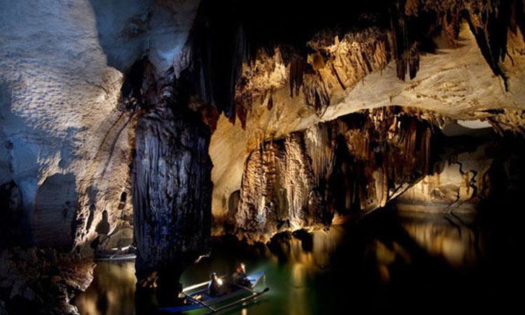
In February ’93, thanks to almost 40 hours of work by helicopter, 2 tons of transferred equipment and complex radio communications, three groups worked for twenty days on the surface and in the depths of the large quartzite plateau of the Auyan Tepui. Works performed on the surface allowed us to draw detailed maps, thanks to modern satellite systems and detailed topographic mapping. We handled with several problems caused by the features of quartz arenite (abrasiveness, hardness on the surface and friability at depth) and with extreme climatic conditions (hard rainfall and sudden floods), nonetheless we were able to study one of the world’s deepest cave in this kind of rock: the Cueva del Rio Pintado (370 m deep, 2500 m long). Explorations of the Aonda and the Sima Churun platforms also produced unexpected results. Further on the data on the lenght of caves, we found clear evidence of the development of complex karst systems within quartzite and we were gaining a better understanding of the genesis of such phenomenon.
During the ‘93 Tepui expedition a documentary film was shot for the TV programme “Reportage” (Canale 5). The film obtained great success, thanks to its filming techniques and it’s amazing settings.

All our explorations

  • Tepui: Explorations at the gates of time Amazonas, border with Brazil and Venezuela - Research on the plateaus of the Amazon basin, through ancient caves, vertiginous walls and impenetrable forests. Geographical
    Read More
  • Palawan, Philippines - The research in the large subterranean estuary of Palawan Island, among long dark lakes, plentiful biology and tropical forests. Geographical area: the island of Palawan, southern-western Philippines, a
    Read More
  • PATAGONIA: GLACIER HYPER-KARST AND EXTINCT POPULATIONSExplorations between crystallized vortices of the Hielo Continental and lost populations.South America is a strip of land that juts out into the vast Southern Ocean,
    Read More
  • SAMARKAND: GIANT REEFS IN A SEA OF SANDExplorations in the deepest caves of Asia, on giant peaks of the Pamir-Alaj Mountains, one of the scenes of the collapse of the
    Read More
  • ALPINE GLACIAL KARST: THE SHAPE OF WATER-HOLESExploration project of “water-holes”, cavities created by melting within large glaciers.Our association has worked on glaciers all over the world for over 20 years
    Read More
  • Temples and underground rivers of the distant Myanmar Geographical Area: Indocina peninsula - Myanmar - Shan State, Central-Eastern Myanmar, about 700 km north-east of Yangon. The peninsula of Indochina contains some of
    Read More
load more hold SHIFT key to load all load all

Questo sito o gli strumenti terzi da questo utilizzati si avvalgono di cookie necessari al funzionamento ed utili alle finalità illustrate nella cookie policy. Se vuoi saperne di più o negare il consenso a tutti o ad alcuni cookie, consulta la cookie policy. Cookie policy