There is an obscure corner of the Earth that sends explorers out into the world..

Karl Kraus, 1909

Follow us on

Latest news from our blog

load more hold SHIFT key to load all load all

The real voyage of discovery consists not in seeking new landscapes, but in having new eyes. 

Marcel proust

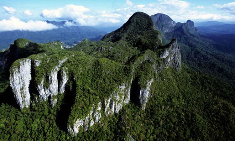
The island of Palawan has a narrow and elongated shape and is mostly mountainous for its entire length, with peaks of over 2000 m. The NE portion is bound on the W by a depression with NS direction. Just E of this discontinuity there is the important karstic area of Mount Saint Paul, 1028 m high, covering a surface of about 35 km2 and consisting of a limestone massive, dark gray, upper Oligocene - Lower Miocene. The formation, over 500 m high, is based on siltstone (fine-grained rocks into sand and clay), sandstone, marl and Oligocene lavas.

The outcrop of carbonate is formed by a long ridge oriented NNE-SSW, bound by the valley of the river Babuyan to E, and by the river Cabayugan to W. The structure is roughly due to a monoclonal dipping NW, bound by faults in NNE-SSW direction. This structural arrangement allows the system to receive contributions from karst sinkholes only from the side of Cabayugan, with the exception of the extreme northern portion, where even on the eastern side we have small marginal basins drained by sinkholes.

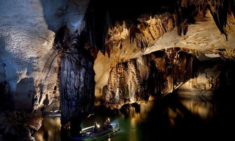
The whole area is affected by intense karst phenomena, typically tropical with superficial forms: towers, cones, cockpit, megakarren, etc... There are numerous explored caves, concentrated in two areas, north and south of the ridge, in addition to the general system of the Underground River, which currently has three entrances and over 32 km of development.

All our explorations

  • Tepui: Explorations at the gates of time Amazonas, border with Brazil and Venezuela - Research on the plateaus of the Amazon basin, through ancient caves, vertiginous walls and impenetrable forests. Geographical
    Read More
  • Palawan, Philippines - The research in the large subterranean estuary of Palawan Island, among long dark lakes, plentiful biology and tropical forests. Geographical area: the island of Palawan, southern-western Philippines, a
    Read More
  • PATAGONIA: GLACIER HYPER-KARST AND EXTINCT POPULATIONSExplorations between crystallized vortices of the Hielo Continental and lost populations.South America is a strip of land that juts out into the vast Southern Ocean,
    Read More
  • SAMARKAND: GIANT REEFS IN A SEA OF SANDExplorations in the deepest caves of Asia, on giant peaks of the Pamir-Alaj Mountains, one of the scenes of the collapse of the
    Read More
  • ALPINE GLACIAL KARST: THE SHAPE OF WATER-HOLESExploration project of “water-holes”, cavities created by melting within large glaciers.Our association has worked on glaciers all over the world for over 20 years
    Read More
  • Temples and underground rivers of the distant Myanmar Geographical Area: Indocina peninsula - Myanmar - Shan State, Central-Eastern Myanmar, about 700 km north-east of Yangon. The peninsula of Indochina contains some of
    Read More
load more hold SHIFT key to load all load all

Questo sito o gli strumenti terzi da questo utilizzati si avvalgono di cookie necessari al funzionamento ed utili alle finalità illustrate nella cookie policy. Se vuoi saperne di più o negare il consenso a tutti o ad alcuni cookie, consulta la cookie policy. Cookie policy