4C_storia
- Details
-
Created: Monday, 18 November 2013 14:39
-
Last Updated: Tuesday, 24 May 2016 07:31
-
Published: Monday, 18 November 2013 14:39
-
Written by Administrator
-
Hits: 97606
The past of Cuatro Cienegas
History and archaeology
In the pre-Hispanic period, the region of today’s state of Coahuila was part of the enormous cultural region known as Arid America, covering the area extending from Northern Mexico to the South-West United States. The region was divided into the following sub-areas: Central and South California, Great Basin, North-West Arizona, Apacheria, Lower California, Sonora and Sinaloa Coast, Southern Texas and Northern Mexico. This last sub-area belonged to the present state of Coahuila. Aztecs used to define Arid America as “The Land of Chichimec”, namely “the land of dogs people”, who were essentially nomads. Arid America had always been the most conservative cultural area of the whole American continent. Up until the period when local populations first came into contact with the Europeans, in these areas “archaic” lifestyles were endured that in other areas had been abandoned thousands of years before. For instance, in Meso America the so-called “Archaic period” lasted approximately until 1800 B.C, meaning that in the whole Arid America (except from a sort of island in the South West of the United States called Oasis America) farming was never performed, ceramics were never used, monumental buildings were never built and states were never created.
Arid American populations were organized in small groups of nomad hunters and pickers and their cyclical movements depended mainly on sources of available water. They survived in the desert environment basing their subsistence on desert plants such as pithayas, yuca roots, agaves, mezcal, palm-trees, roots and tubers, indian figs, on animals like foxes, hares, rabbits, rats, snakes, birds, insects and on natural products like honey.
All groups were commanded by a head-man. Normally they occupied leading positions because of their personal status and they headed fights against rival groups. People used to live naked or wearing vegetal fibre or leather loincloths. They used to walk using sandals made of interweaved fibres. They had long hair, loose or braided, tied up with a coloured band on the forehead. They were very keen on creating tools, for instance they used to weave baskets, build wooden darts with flint tips which were thrown through propellers, stone grinders and pestles to grind the seeds they picked and working tools made of bone or horn.
Very little is known about their religious and spiritual practices. We know that they used peyote in order to have visions during ceremonies and while dancing through the music of drums, bells, pumpkins and snake rattles. They certainly possessed a well-articulated oral tradition. In fact,
we know that in some cases they used to wrap dead bodies in wicker mats or tie them up in funerary bundles. Considering the situation, it is not surprising if Aztec informers of Bernardino de Sahagún described “the Land of Chichimec” as follows:
“It is a land of misery, of sorrow, of suffering, exhaustion, of poverty and anguish. It is a land of dry rocks, of failure, a place of lament, of death, thirst, of starvation. It is a place of much hunger and death.”
Ethnic history of Cuatro Ciénegas
The historical and ethnographic documentation of the colonial era, regarding the period between 1650 and 1750, proves that the region of Cuatro Ciénegas was populated in this century by various indigenous groups, known as the Coahuileños or Coahuilas, who were widespread in the whole region, north and north-east of the district of Parras-Laguna.
These groups, belonging to the hokano-coahuilteca language group, lived in the area extending from Mapimì to Monclova and Cuatro Ciénegas. According to historical sources, in the region of Cuatro Ciénegas, there lived among others, groups known by the following names: Cabezas, Salineros, Cíbolas, Baborizagames, Baborimamas, Corcobados, Ygoquibas, Yguitoros and Contotores.
It is difficult to find out if names mentioned in various documents referred to ethnic groups, “gangs”, or even to simple family groups. These gangs were normally united by unstable and ephemeral alliances and wandered in the region performing raids against rival groups. In many cases gangs of Coahuileños were allied with (or, alternatively fought against) the Tobosos, a large group of vague affiliation populating the northern regions of Coahuila. It is likely that the habit of forming large alliances, often under the guidance of one single leader, was an innovation of the colonial era, due to the presence of a new common enemy: the Spanish invaders.
The fight against Spanish colonisers caused a rapid decline in native groups of the area and by the mid XVIII century they had almost completely vanished.
New indigenous groups benefited from this situation and moved into the lands of today’s state of Coahuila. Populations that moved in this region were the uto- Aztec, the Comanche and above all, from 1740-50, the Apache, an indigenous group belonging to the Athabaskan language group, whose origins were to be found in what is today Canada. This group occupied almost the whole region. However, they too very soon became a target of the new colonial world. In fact, nowadays native inhabitants of the region of Coahuila have almost entirely disappeared.
Archaeological research in Cuatro Ciénegas
Among various regions of Arid America, the area of today’s state of Coahuila has been carefully studied on an archaeological level and is the source of most of the available data on the Arid American prehistory.
The Bolsón of Cuatro Ciénegas and the nearby canyons were explored between 1937 and 1947 by Walter W. Taylor during his Coahuila Project, which was partially funded by the United States National Museum of the Washington’s Smithsonian Institute. Taylor explored several caves of the region (ignoring the rare and poorly preserved open air sites), though results of researches were only partially published.
The archaeological heritage of the region of Cuatro Ciénegas is essentially characterised by cave sites and forms of cave art. In cavities all over the region traces of temporary human activities were discovered, fireplaces, several tools used for daily activities. Also various funerary sites were discovered, where dead bodies were wrapped in mats and covered with masses of stones. Cave art is particularly abundant and generally characterised by geometrical images of various colours, such as red, yellow and ochre. In some cases vertical and long anthropomorphic images can be observed, perhaps depictions of “spirits” of men during ecstatic experiences.
Research performed by the La Venta Association during the Cuatro Ciénegas Project do not have (at least for now) specific archaeological purposes, however throughout explorations of the area we have surprisingly found several archaeological elements, such as arrow heads, cave paintings and numerous funerary sites one of which was characterised by the presence of mats.
The main discovery has certainly been a refuge with a 30 m rock wall, covered with wonderful polychromic paintings. All archaeological findings have been documented with numerous photos and, clearly left in situ without altering their original conditions.
The archaeological sequence of Cuatro Ciénegas
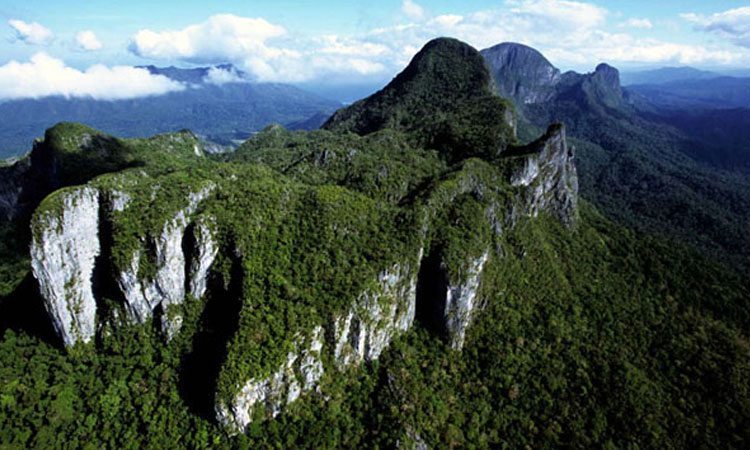
The most ancient archaeological findings discovered in the state of Coahuila date back to the end of Pleistocene and consist of spearheads found in the Cueva Espantosa and in La Chuparrosa. However, at the beginning of the Holocene some of the most important cultural traditions of the area developed, related to the so-called “Desert Tradition”, represented mainly by the Bolsón of Cuatro Ciénegas.

The Puerto Princesa Underground River (PPUR)
- Details
-
Created: Monday, 18 November 2013 14:39
-
Last Updated: Thursday, 26 May 2016 08:45
-
Published: Monday, 18 November 2013 14:39
-
Written by Administrator
-
Hits: 77125
The cave consists of a main axis, developing in the direction NNW-SSE, about 7 km long and formed by a large gallery crossed by the river. The main gallery has several branches, and some modest tributaries, especially from the left. The main tributary is the Australian 's Inlet, just downstream of the Rockpile, coming from a depressed area located just south of the Barrio of Sabang. Another small left tributary is located not far from the daylight. On the right side, the only noteworthy tributary is located about 1 km upstream from the Rockpile, and comes from a short branch closed by a siphon.
Parallel galleries at altitudes close to sea level, develop especially on the left side of the main branch, in its middle and lower part (Cin Gallery). Part of these galleries is reactivated during floods, as evidenced by the presence of significant alluvial deposits. At the bottom of the underground river develop other small parallel galleries, semi-flooded, giving rise to a sort of grid of twisted channels, typical of estuarine intertidal zones (areas located between high and low tide).
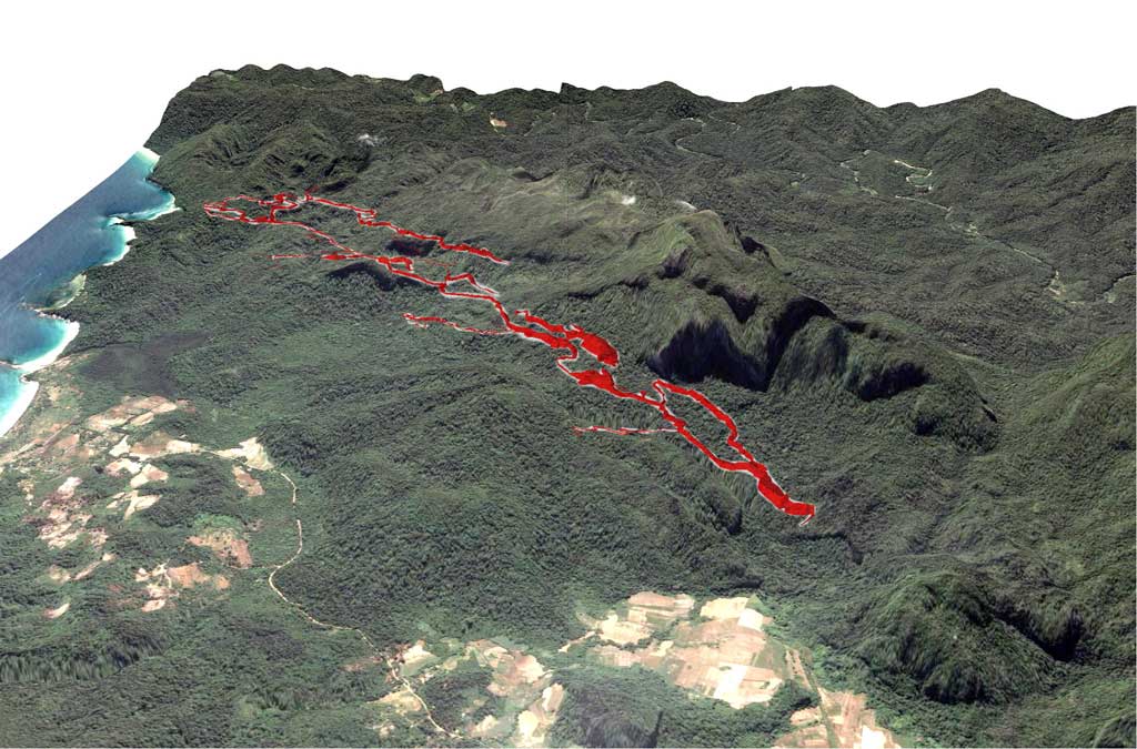
One of these lateral branches, which starts on the right side about 150 m upstream of the entrance of the valley, spreads a few meters above sea level up to an impressive stalagmite flow beyond which the gallery continues gaining considerable size and gorge morphology. In fact, we have entered a sort of parallel way of the river, whose existence was suspected from some time, fed by infiltration water collected from karstic massif and not from sinkholes, so active only during the wet season.
The gallery (150 years gallery) in some places has widths up to 30 m and heights of 40-50 m and extends for approximately 4 km towards SW, then parallel to the main river, but a few dozen of meters higher. The morphology is that of a large underground canyon with erosion terraces on the walls and alluvial deposits. For long stretches the walls are covered with spectacular crystal coralloid and eccentric concretions. The gallery ends with a great landslide (Magellan Chamber), close to the great halls that are above the main river. Below this gallery we find some branches with clearly epiphreatic morphologies, probably formed by the periodic ascent of the piezometric surface.
In the southern portion of the underground karst system there are, however, some large upper branches (Halohalo Gallery), on the right side of the current active route, which represent segments, now divided by slumping or fills, of an ancient route of the underground river with tunnels that have dimensions generally larger than those of the current collector. Where is preserved the original shape of the duct, the portion of the floor is about 50-60 m upper the sea level. Many sectors have been subject to slumping, that have expanded the size, creating large rooms such as the Italian's Chamber, which has a length of 300 m, a maximum width of 140 m and an estimated height of 80 m, with a volume of approximately 2.5 million cubic meters.